|
| |
Elias Cambranes , your independent tour guide, is licensed in Belize and Guatemala.
Please bring drinking water, food, swim suit, sun tan lotion, and insect repellent.
Entrance fees are not included in the tour prices except for Tikal.
K'ATUN AHAW HOME | TOURS | CONTACT & LINKS | GUESTBOOK
Tikal Pictures 1 | Tikal Pictures 2 | Tikal Pictures 3
Caracol Pictures 1 | Caracol Pictures 2
|
|
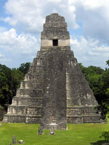
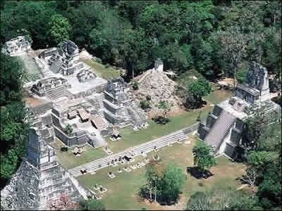
Tikal Day Tour
|
Titkal is the largest of the ancient ruined cities of the Maya civilization. It is located in Guatemala and is an UNESCO World Heritage Site.
Tikal was one of the major cultural and population centers of the Maya civilization. Though monumental architecture at the site dates to the 4th century BC, Tikal reached its apogee during the Classic Period, ca. 200 AD to 850 AD, during which time the site dominated the Maya region politically, economically, and militarily while interacting with areas throughout Mesoamerica, such as central Mexican center of Teotihuacan. There is also evidence that Tikal was even conquered by Teotihuacan in the 4th century A.D. Following the end of the Late Classic Period, no new major monuments were built at Tikal and there is evidence that elite palaces were burned. These events were coupled with a gradual population decline, culminating with the site’s abandonment by the end of the 10th century.
Tikal had no water other than what was collected from rainwater and stored in underground storage facilities (termed chultuns). Archaeologists working in Tikal during the last century utilized the ancient underground facilities to store water for their own use. The absence of springs, rivers, and lakes in the immediate vicinity of Tikal highlights a prodigious feat: building a major city with only supplies of stored seasonal rainfall. Tikal prospered with intensive agricultural techniques, which were far more advanced than the slash and burn methods originally theorized by archeologists. The reliance on seasonal rainfall left Tikal vulnerable to prolonged drought, which is now thought to play a major role in the Classic Maya Collapse.
The ruins lie on lowland rainforest. Conspicuous trees at the Tikal park include gigantic ceiba (Ceiba pentandra) the sacred tree of the Maya; tropical cedar (Cedrela odorata), and mahogany (Swietenia). Regarding the fauna, agouti, coatis, gray foxes, spider monkeys, howler monkeys, Harpy Eagles, Falcons, ocellated turkeys, guans, toucans, green parrots and leaf-cutting ants can be seen there regularly. Jaguars Jaguarundis and Cougars are also said to roam in the park.
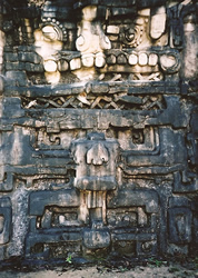
There are thousands of ancient structures at Tikal and only a fraction of these have been excavated after decades of archaeological work. The most prominent surviving buildings include six very large Mesoamerican step pyramids, labeled Temples I - VI, each of which support a temple structure on their summits. Some of these pyramids are over 60 meters high (200 feet). They were numbered sequentially during the early survey of the site.
 |
We leave from our office at Casa Blanca Guesthouse at 7:30 for a ten miles drive to the Belize / Guatemala border. We will also pick you up form your hotel.
Border paper work and fees take about a half an hour, followed by two hours of driving time on a combination of dirt road and pavement for 60 miles to Tikal. The drive is very scenic, many farm communities are seen on the way and many farm animals are usually on the road too. This is an excellent opportunity for photography from start to finish. |
The guided tour of Tikal takes 4 hours. You will see lots of wildlife. The Tikal national park covers 222 square miles of rainforest that has not been in habited for 1,000 years so the rainforest is at its best, a primary rainforest .
A lunch is serve at one of the restaurants of the site, shopping time is always available and for the adventurous "The Canopy Tour" is an option (zip-lining).
Tours departure any day of the week at
7:30 a.m. from the Casa Blanca Guesthouse on 10 Burns Avenue, San Ignacio, Cayo.
2 to 10 persons
We return back to San Ignacio around 5:30 pm.
|
|
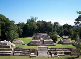
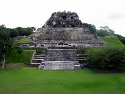
Caracol
Caracol or El Caracol is the name given to a large ancient Maya site located in the Cayo District. Caracol is about 25 miles south of Xunantunich and San Ignacio, at an elevation of 1500 feet (460 m) above sea-level, in the foothills of the Maya Mountains. The name is Spanish for "The Snail"; the ancient Maya name may have been Oxhuitza.
Caracol is the largest Maya archaeological site in Belize. In AD 650, the urban area of Caracol had a radius of approximately 10 kilometers around the site's epicenter. It covered an area much larger than present day Belize City (the largest metropolitan area of Belize) and supported more than twice the modern city's population. Urban Caracol maintained a population of over 140,000 people through the creation of an immense agricultural field system and through elaborate city planning. Caracol is noted not only for its size during the Maya Classic era (A.D. 250-950), but also for its prowess in war; this includes an AD 562 defeat of Tikal (Guatemala) and a subsequent conquest of Naranjo (Guatemala) in AD 631.
One monument here records a military victory over the army of Tikal in AD 562, where Caracol's Lord Water is shown to have captured and sacrificed Tikal's Double Bird. This event is seemingly concurrent with archaeological and epigraphic evidence indicating the beginning of the Tikal Mid-Classic Hiatus, when a seeming decline in Tikal's population, a cessation of monument building, and the destruction of certain monuments in the Great Plaza occurred as Caracol's population and urban development seemingly skyrocketed.
tikaldaytrip@yahoo.com |
|
Barton Creek Cave & Green Hills Butterfly Farm |
|
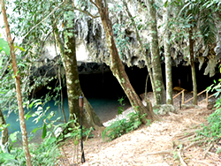
Welcome to the Maya underworld and ancient place of worship. Barton Creek Cave was used for burial and other ceremonial purposes. Barton Creek Cave is a large river cave that may extend up to 4.5 miles (7.2 km) and has not been fully explored. It is accessible only by boat, and archaeological investigation have uncovered a large number of Mayan relics from the various ledges above the river, suggesting it was used for rituals. After the tour of the cave visit the Green Hills Butterfly Farm and
see over 15 species
of tropical butterflies.
tikaldaytrip@yahoo.com |
|
Jaguar Paw Caves
Belize has one of the most extensive cave systems in Central America. The Maya used the caves for shelter and ceremonial purposes. Our tour will follow forest trails with an abundance of flora and fauna. You will tube down the Caves Branch River system on tubes through amazing caves and caverns.
tikaldaytrip@yahoo.com |
|
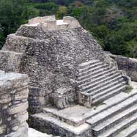
Cahal Pech / El Pilar / Xunantunich
A full day of exploring the Maya World and seeing nature at its best. |
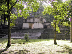 |
Cahal Pech was a home for an elite Maya family. Evidence of continuous habitation has been dated to as far back as 900 BC, making Cahal Pech one of the oldest recognizably Maya sites in Western Belize. The site sits high near the banks of the Macal River and is a collection of 34 structures, with the tallest being about 25 meters in height. The site was abandoned in the 9th century AD for unknown reasons. Cahal Pech is now an archaeological park, and houses a small museum with artifacts from various ongoing excavations.
|
 |
El Pilar is an ancient Maya city, located in the Cayo District straddling the Belize-Guatemala border, 12 miles (19 km) north-west of the town of San Ignacio. It is the largest site in the area with over 25 plazas and covering around 50 hectares. Little archaeological work has been undertaken, but there is a series of trails allowing access to the site. In 1997 El Pilar was listed on World Monument Fund's 100 Most Endangered Sites in the World. It is managed as an Archaeological Reserve for Maya Flora and Fauna. |
 |
Xunantunich (shoo-NAHN-too-nich) is located atop a ridge above the Mopan River, within sight of the Guatemala border. Its name means "Stone Woman" in the Maya language and, like many names given to Maya archaeological sites, is a modern name; the ancient name is currently unknown. The "Stone Woman" refers to the ghost of a woman claimed by several people to inhabit the site, beginning in 1892. She is dressed completely in white, and has fire-red glowing eyes. She generally appears in front of El Castillo; ascends up the stone stairs and disappears into a stone wall.
|
Most of the structures date from the Maya Classic Era, about 200 to 900. There is evidence that some structures were damaged by an earthquake while they were occupied; this earthquake may have been a reason for the site's abandonment.
The core of Xunantunich occupies about 1 square mile (2.6 km²), consisting of a series of 6 plazas surrounded by more than 26 temples and palaces. One of its structures, the pyramid known as "El Castillo," the second tallest structure in Belize (after the temple at Caracol), at some 130 feet (40 m) tall. Archeological excavations have revealed a number of fine stucco facades on some of the ancient temples of this site. Evidence of construction suggests the temple was built in three stages in the 600s AD, 700s AD, and 800s AD. |
tikaldaytrip@yahoo.com |
|
Mountain Pine Ridge
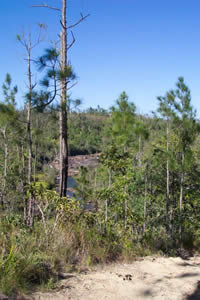 |
Mountain Pine Ridge Forest Reserve is a nature reserve in the Cayo District of southern central Belize. It was established in 1944 to protect and manage the native pine forest. Its boundaries are poorly defined, but it is estimated to cover an area of 106,352.5 acres (430 km²), although much of the reserve has been leased.
The reserve is predominantly pine forest , primarily Caribbean Pine, Pinus caribaea, but with significant broadleaf forest. There are small areas of grassland and wetland.
The majority of the reserve is situated on a granite massif, with some areas of limestone in the west of the reserve (remnants of a limestone plateau laid during the Jurassic). Sinkholes and caves are common in the limestone areas. The underlying soils are predominantly sandy. The elevation of the reserve averages between 400 and 700 m (1,312 to 2,296 ft) with the highest point being Baldy Beacon at 1,017 m (3,336 ft), and dropping to 120 m (394 ft) at the lowest point of the Macal River.
The Macal River forms the boundaries of the reserve to the west and south and is fed tributaries including Rio Frio, Rio On, Privassion Creek and Piviol Creek. To the north-east some small streams feed into Barton Creek.
The reserve is home to various large mammals: the Cougar, the Jaguar, the Ocelot, the Coatimundi, and Baird's Tapir. There is a small population of Morelet's Crocodile.
Native species of bird include the Rufous-capped Warbler, Crossbill, Pine Siskin, Eastern Bluebird, Stygian Owl, King Vulture, Ocellated Turkey, Acorn Woodpecker, Blue-crowned Motmot, Plumbeous Vireo, Keel-billed toucan and Red-lored Parrot. Winter visitors include the Hepatic Tanager and Chipping Sparrow. Orange-breasted Falcons are more common in the area than elsewhere in Belize.
The pine forest has been seriously damaged by the Pine Bark Beetle, Dendroctomus frontalis, with 80% of the trees showing signs of attack. |
tikaldaytrip@yahoo.com |
|
K'ATUN AHAW HOME | TOURS | CONTACT & LINKS | GUESTBOOK
Tikal Pictures 1 | Tikal Pictures 2 | Tikal Pictures 3
Caracol Pictures 1 | Caracol Pictures 2
© 2008 - 2012 K'atun Ahaw Culture & Eco Adventure Tours. All Rights Reserved. Created by Kolibri Web Design
|
|
|
|